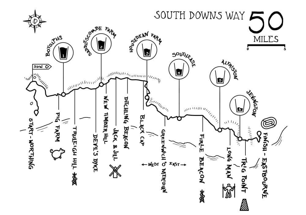
The South Downs tower over Southern England affording runners awe inspiring views north across the Weald and the coast/ English Channel. As with all Centurion events, runners will be fully supported by 6 well stocked aid stations, full medical support and a marked course. Race held under full UK Athletics Permit granted through the TRA (Permit Number 1675).

Distance
50mi
81KMs
Elevation
5700ft
1750m
Cut-off
13hours
Entry Fee
£80
Date
7 Apr 2018 08:30
Course Marked
YES
Medical Support
YES
No. of Starters
400
Avg Temp.
9C
48.2F
Avg Rainfall.
55mm
2inches
Avg Humidity
60%
# of Aid Stations
7
Location
EU / UK / ENGLAND / SOUTH-EAST
Terrain
15% road / 85% trail
Entries for 2018 will open at 1000 on Saturday June 24th 2017. There will be 460 places for the event on open registration (plus 40 places for 2017 Volunteers). Places are open on a first come, first served basis. Entrants must meet the minimum qualification standard below in order to apply. There will be a wait list in operation, once the initial places are taken.
Entry fee is £80. There are no additional card fees.
In order to enter you must have completed a minimum of a marathon distance race within the cut off time of that event between 1st January 2015 and race day. As organisers, we reserve the right to refuse anybody entry who does not meet this standard. Unqualified runners may enter but will be contacted approximately 8 weeks prior to race to verify qualification plans if they have not updated their online information by this time.
Click here to read more about what counts as a qualifier.
Runners must finish the course within a 13 hour time limit. There are additional cut offs at each aid station on route (see aid station table for full details).
Registration and the race start is at Hillbarn Recreation Ground, Hill Barn Lane, Worthing, West Sussex BN14 9QF. Grid ref: 142050.
The race finishes at Eastbourne Sports Club Athletics Track, Cross Levels Way, Eastbourne, BN21 2UF. Runners will enter the track through the gate and complete a lap of the track to finish. Runners will be permitted to run the track section with friends, family and crew accompanying them.
The race route travels from Hillbarn Rec on public footpaths to join the South Downs Way just before Chanctonbury Ring. The route then follows the SDW all the way to Eastbourne, only deviating from the standard course at the points listed on the course page. Of particular note is the junction at Alfriston where runners will take the bridleway path over Windover Hill to Jevington and on to Eastbourne, as opposed to the Seven Sisters footpath route.
A map of the route and a downloadable GPX file can be found at the bottom of this page. There is 5700 feet of climb in the race.
Medal & T-Shirt to Finishers only.
Additional prizes will be awarded to First place Male and Female.
There will be 7 aid stations including the finish along the length of the course. A full list of the aid stations and all opening closing times can be found here. All aid stations carry as a minimum: water, coke, chocolate, sweets, sandwiches, nuts, lots of fruit, Gu gels, wraps, sandwiches and other sweet and savory snacks.
Finish Line Bags can be deposited at registration and should be clearly labelled with runners name and bib number.
The course is marked by South Downs Way marker posts which come in different forms but always displaying the acorn which is the key symbol and guide on this route as with all National Trails.
In addition to the fixed markers as above, the course will also be marked with red & white tape and Centurion marker arrows. There are a number of road crossings to negotiate, some of them are extremely busy and will NOT be marshalled. It is the responsibility of the runner to negotiate all road crossings safely.
It is ultimately the runners responsibility to navigate the course successfully, with or without course markings. We strongly recommend that you take the time to recce the route before race day & carrying a map and compass are highly recommended for the event in case of an emergency. The Harveys South Downs Way map available at a discounted rate here, is an excellent guide.
No pacers are permitted at any point on the route. The exception to this is the finishing lap of the track where a runner may be joined by as many friends and family as he or she wishes.
Runners are allowed to have a crew. The points at which a runner may be crewed are listed on the crew page here. Crews will not be permitted to crew for their runner at any point other than those listed. Crews must adhere to the rules for crews contained within the infopacks.
There will be a dedicated team of race medics available throughout the duration of the weekend including static first aid teams, rapid response cars and race ambulances. If you suffer an injury or accident that warrants direct medical attention, the medics will be on hand to provide you with exactly that. Contact numbers and full details of what to do in an emergency will be given to you in the pre race information packs and again at race registration. Due to the nature of the course ie. some remote and far from roads, the medics may take some time to reach you, or potentially be out of contact tending to other runners. In those instances you should contact the emergency services on 999. Full instructions on what to do in an emergency can be found in the infopacks.
85% of the course is on trail, therefore trail shoes are advised. There are sections of trail which can become very muddy in wet conditions. The South Downs are formed of chalk and are composed of significant sections of exposed and slippery chalk bed and rocks. These sections must be negotiated carefully in both the dry and the wet. The ridge is very exposed and in wind and rain runners can become cold quickly. Visibility can also be extremely poor under cloud cover. It is essential to carry the items below in lieu of these potential outcomes. There will be kit checks prior to the race as well as potientially during and at the finish. Runners must carry the following mandatory equipment at all times. A time penalty of one hour will be imposed for any item found to be missing at any point on course. Please refer to this page for explanations on the inclusion of the below items.
There are many options regards kit for fulfilling these requirements and those of other events. We stock what we believe to be the best options at our online store available by clicking here under the Mandatory Gear Section. Please ask us if you have any questions.
Strongly recommended but not mandatory:
